Quinte Conservation is holding a public information centre on Dec. 3 regarding updated floodplain mapping for areas along Potter’s Creek. This floodplain covers a portion of the western half of the city. The study aims to manage flood risk and ensure sustainable development practices for the region.
The information session will be held on Dec. 2 from 5 to 7:30 p.m. at the Holy Trinity Evangelical Lutheran Church (516 Victoria Ave.).
- When: Wednesday, December 3, 2025
- Time: 5:00 p.m. – 7:30 p.m.
- Location: Quinte Conservation Office, 2061 Old Hwy#2, Belleville
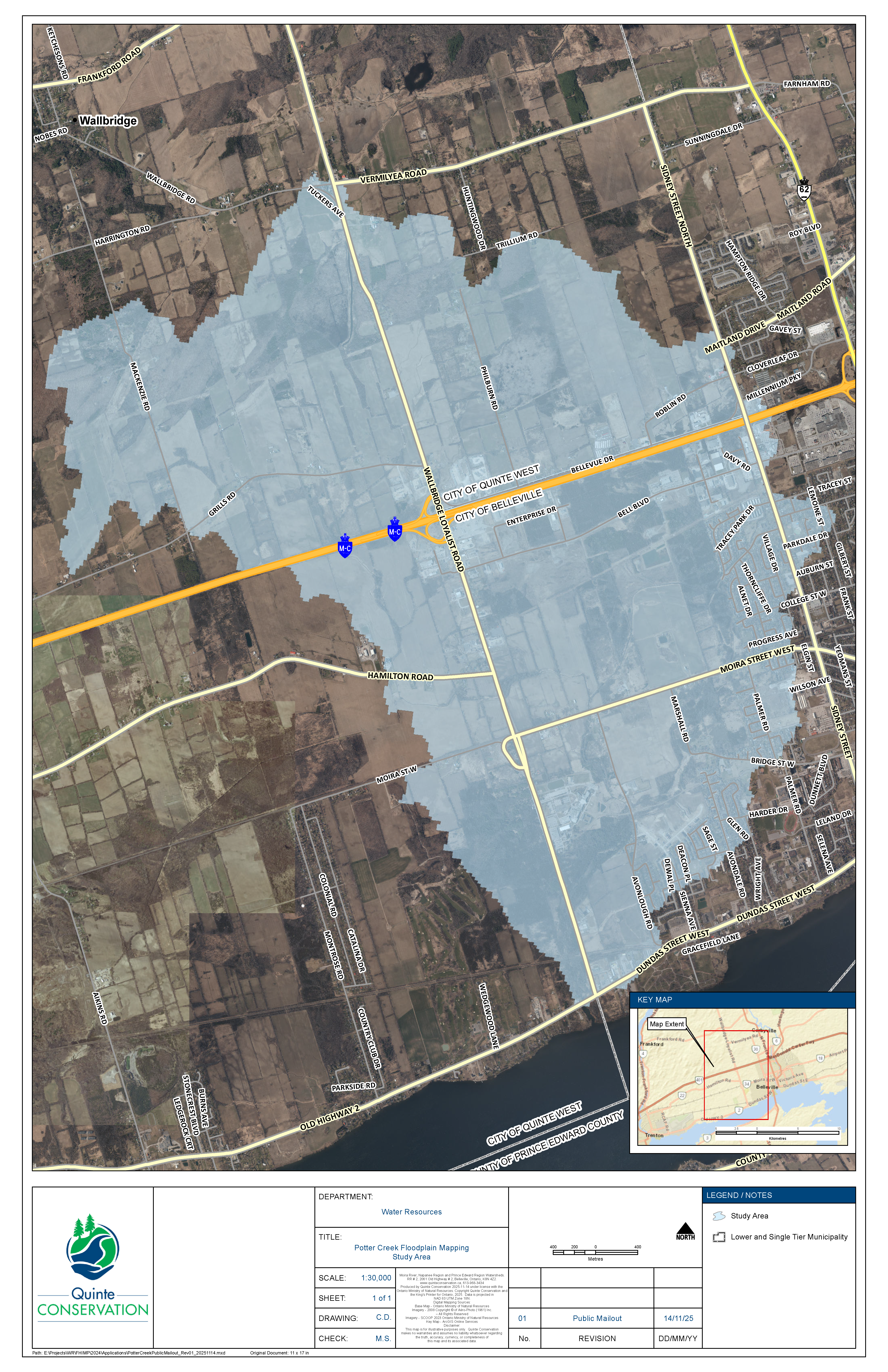
Quinte Conservation is conducting a study to update the floodplain maps for Potters Creek, with support from the City of Belleville and grant funding from the Flood Hazard Identification and Mapping Program (FHIMP). This study aims to revise the existing floodplain mapping for Potters Creek, which was originally completed in 1993.
The Potters Creek watershed covers 30 square kilometers and includes a 31 km long watercourse. Updated the Potter’s Creek Floodplain Mapping can help homeowners, developers, and the City make better decisions about flood protection, insurance, and infrastructure planning. It may also impact which areas are considered at risk of flooding in future development or emergency response plans.
The study will address the following components:
- Adherence to the province’s Flood Hazard Identification and Mapping Program – Program Guide, detailing the requirements for the Floodplain Mapping Project.
- Generation of updated flood hazard maps, incorporating data collection, hydrologic analysis, and hydraulic modeling.
- Exploration of flood reduction measures in the area bounded by Moira St W to the south, Wallbridge-Loyalist Road to the west, and existing developments to the east.
There have been advancements in hydrologic and hydraulic modeling since the last mapping project, necessitating the creation of new floodplain mapping. This updated mapping will enhance flood risk assessment and management at the local level. In addition to the regulatory 100-year storm event, events corresponding to the 2-year, 5-year, 10-year, 25-year, 50-year, 200-year, and 350-year frequencies will be analyzed and mapped to assess their impacts.
Natural hazard maps are important tools used by municipal governments, Conservation Authorities, and planning agencies to guide development, zoning, and emergency preparedness. These maps are used when reviewing development applications to assess natural hazards such as flooding, erosion, and steep slopes, which can pose risks to both people and property. For properties within the floodplain or associated setbacks, development requires approval from Conservation Authorities before building permits are granted.
The last floodplain mapping for Potter Creek was developed in 1993 and is being updated to reflect changes in land use and climate data. Using advanced floodplain mapping tools such as topography, bathymetry, water resource modeling, and field surveys, the study aims to accurately delineate flood-prone areas and provide a clearer understanding of flooding hazards during various storm events. This mapping will help to better inform future development decisions, land use planning, and flood mitigation strategies in the region.
This project is supported by the Government of Canada, the Province of Ontario and the City of Belleville.


Comments
We want to hear from you! Share your opinions below and remember to keep it respectful. Please read our Community Guidelines before participating.