A geographic code is a numerical identifier assigned to a geographic area. Every kind of geographic area in Canada has its own type of geographic code.
For example, the geographic code assigned to a census subdivision (CSD) makes it possible to distinguish that CSD from any other CSD with the same name. The code is used to identify and access standard geographic areas for the purposes of data storage, retrieval and display.
SGC Code
The Standard Geographical Classification (SGC) is Statistics Canada’s official classification system of names and codes representing areas of Canada.
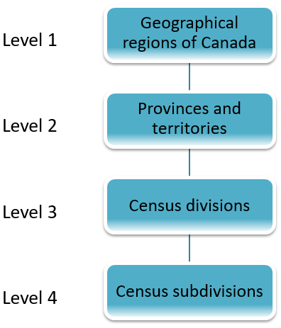
The classification provides names and codes for four levels of geography:
- Geographical regions
- Provinces and territories
- Census divisions (counties, regional county municipalities)
- Census subdivisions (municipalities)
It consists of a three-tiered hierarchy – province or territory, census division, and census subdivision. Each geographic area receives a unique numeric code ranging from 1 to 7 digits in 1 to 4 parts (XX YY ZZZ):
- XX: Province or territory
- 48 Alberta
- 59 British Columbia
- 46 Manitoba
- 13 New Brunswick
- 10 Newfoundland and Labrador
- 61 Northwest Territories
- 12 Nova Scotia
- 62 Nunavut
- 35 Ontario
- 11 Prince Edward Island
- 24 Quebec
- 47 Saskatchewan
- 60 Yukon
- YY: Census divisions
- ZZ: Census subdivision (municipality)
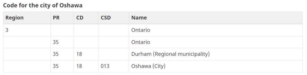
Example
- 35 represents Ontario
- 18 represents Durham Region
- 013 represents the City of Oshawa
More: Standard Geographical Classification (SGC) 2021
Lower levels of Census geography such as Census Tracts (CTs), Enumeration Areas (EAs) prior to 1996, and Dissemination Areas (DAs) from 2001 onward, are less commonly used for collection of health data but can be used for analysis based on recoding from the postal codes (see later discussion of postal code system). CTs, EAs and DAs are available for Census data 2 and can be useful for regrouping into some level of geography lower than the CSD level for “community level” analysis. Most data produced by Statistics Canada uses this system including Census data, population estimates and projections.
DGUID
Dissemination Geography Unique Identifier (DGUID) is an alphanumeric code, composed of four components. It varies from 10 to 20 characters in length. The first 9 characters are fixed in composition and length.
- Vintage (4) + Type (1) + Schema (4) + Geographic Unique Identifier (2-11) :
- VVVV T SSSS GGGGGGGGGGG
- Vintage is a four digit code (e.g., 2021) indicating the reference year of the geospatial data.
- Type is a one character code (e.g., A) indicating the type of geographic areas. At this time there are five geographic area types:
- A Administrative areas
- S Statistical areas
- C Combined areas
- B Blended areas
- Z Other
- Schema is a four digit sequential number (e.g., 0005) assigned to each unique geographic area defined by type.
- 0000 Country
- 0001 Geographical region
- 0002 Province or territory
- 0003 Census division
- 0004 Federal electoral district
- 0005 Census subdivision
- 0006 Designated place
- 0007 Health region
- 0008 Local health integration network
- Geographic Unique Identifier is a variable length alpha‑numeric code (e.g., 3520005) assigned to each individual geographic area. For more detail see the Geographic Code definition. The Geographic Unique Identifiers range from 1 to 12 characters in length.
- CDUID – 4 character ID that uniquely identifies a census division (composed of the 2-digit province or territory unique identifier followed by the 2-digit census division code).
- CCSUID – 7 character ID that uniquely identifies a census consolidated subdivision (composed of the 2-digit province or territory unique identifier followed by the 2-digit census division code and the 3-digit census consolidated subdivision code).
- CSDUID – 7 character ID that uniquely identifies a census subdivision (composed of the 2-digit province or territory unique identifier followed by the 2-digit census division code and the 3-digit census subdivision code) in the 2017 Census Subdivision Boundary File.
ALT_GEO_CODE
alternate geographic code that is usually equal to the ending digits of the DGUID and is often the geographic code found in previous census cycle products.
SLC Code
SLC uniquely identifies the Schedule, Line and Column of each data point within the Financial Information Return (FIR).
Each SLC code is structured as:
slc.02X.L0020.C01.02
- all slc references begin with “slc.”
- 02X refers to the schedule number. In this example it is referring to Schedule 02. In most cases, the schedule number is followed by an X.
- i.e. Schedule 10 would be slc.10X. (e.g., 10X for Schedule 10: Revenues). However, where a schedule is divided into different parts (i.e. Schedule 26 is divided into two tabs in the FIR template; Schedule 26A and Schedule 26B) the schedule portion of the slc will be slc.26A and slc.26B. Other schedules where this applies include: Schedule 51, Schedule 72 , Schedule 74, Schedule 77 and Schedule 80.
- L0020 refers to the line number. In this example the line number is 0020.
- 01.02 refers to the section and column number. In most cases the section will However where a schedule has distinct sections, the section number will change. For example, Schedule 20 is divided into different sections with varying number of columns in each section.
They allow for:
- precise referencing and cross-referencing of financial data across schedules.
- automated calculations and carry-forwards from one schedule to another.
MAH Code
Municipal Affairs and Housing Code (MAH Code) which is associated with the municipality (also known as TEIGA (Treasury Economics and Inter-Governmental Affairs) code). The code is unique over time. That is, even through status changes and new municipalities come into being as a result of amalgamations, previously used codes are retired, and never re-used. This code is used for structured sorts. It must be unique within the Ministry of Municipal Affairs and Housings Municipal Analysis and Retrieval System (MARS) database. Because this code changes when the status of the municipality changes, it is not used as a unique identifier. This code is carried as a historical reference and to link to older data systems.
The MAH Code is a five-digit code which is unique to each municipality in the province. The five-digit MAH Code is divided into three parts (XXYZZ):
- First 2 digits (XX): Code which identifies the Region, County, or District where the municipality is located.
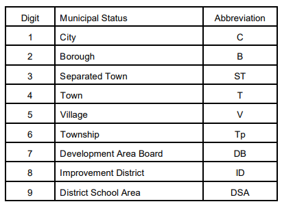
- 3rd digit (Y): Code which identifies the Municipalities status according to the following table:
- Last 2 digits (ZZ): Represent a sequential ordering of Municipalities of the same status in the same Geographic region, county, or district.
3rd digit
Example
27401 Town of Aurora (in York Region)
- 27 Represents York Region
- 4 Represents Town
- 01 Identifies Aurora as Town 1 in the Region
Municipal Assessment Code
Municipal Assessment Code (ASMT Code) which is a four-digit code which is unique to each municipality in the province used by the Municipal Property Assessment Corporation (MPAC) to identify properties in the assessment roll.
A municipal code provided by the Municipal Property and Assessment Corporation (MPAC) (formerly Ministry of Revenue). It is also known as the Revenue Code. The four-digit code made up of two portions: the first two digits describe the geographic Upper Tier in which the municipality is located, the second pair of digits uniquely describe the Lower Tier Municipality within the geographic Upper Tier.
Since MPAC maintains assessment data only at the Lower Tier level, this code has been made-up for Upper Tier Municipalities in the Municipal Analysis and Retrieval System (MARS) data base. The code in MARS also had to be made-up for the new City of Toronto after the 1998 amalgamation, since MPAC continued to carry the codes of the former municipalities.
The first 4 digits of properties roll number begins with this code. It is split into 2 parts (XXYY):
- First 2 digits: Identifies the Region, County, or District where the municipality is located.
- Last 2 digits: Identifies each Municipality
Example
1946 Town of Aurora (in York Region)
- 19 Represents York R
- 46 Represents Aurora T
MSO Code
MSO Code is a 2 digit code to identify the Municipal Service Office.
MOHLTC Residence Coding System
The Ontario Ministry of Health and Long Term Care (MOHLTC) bases all geography on the MOHLTC Residence Coding System. The lowest level (4 digits) represents municipalities, townships, named settlements, First Nations Reservations, and unorganized areas. These geographic units are the basis of the Public Health Unit geography. Most data coming from Statistics Canada, including population estimates and projections and vital statistics must be regrouped into Residence Codes based on Census Sub Division (CSD). Because some CSDs map to more than one Residence Code, decisions regarding the assignment of CSDs to unique Residence Codes are made by the MOHLTC. Residence Codes reflect changes in the municipal boundaries that occur between Census years whereas Statistics Canada’s data is based on CSDs from the most recent Census.
The next highest level of geography for MOHLTC is the county/district. Counties are created by grouping 4-digit Residence Codes together and therefore differ somewhat from Statistics Canada’s Census Divisions (based on groupings of CSDs). In many cases these geographies match; most differences are related to where First Nations Reservations are placed. Statistics Canada splits Reserves across CDs whereas MOHLTC selects one county to place the entire reserve.
In many cases public health units consist of either single or groups of counties or CDs, however, in some cases (marked with an asterisk in Table 1 below) a CD will fall into more than one health unit area. (see map of Ontario Public Health Unit and County Boundaries) For this reason, when
aggregating data which is based on census geography, it is preferable to group CSDs rather than CDs into health units. Some current health units are a result of past amalgamations of health units, these are highlighted in Table 2 below. As of June 2006, there are 36 public health units in
Ontario.
TABLE 1: Public Health Units by Census Division
| Region Name | Public Health Unit Name | County Name |
| Central East | Durham Region Health Department | Durham |
| Haliburton, Kawartha, Pine Ridge District Health Unit | Haliburton | |
| Northumberland | ||
| Kawartha Lakes | ||
| Peterborough County-City Health Unit | Peterborough | |
| Simcoe Muskoka District Health Unit | Simcoe | |
| Muskoka | ||
| York Region Health Services Department | York | |
| Central South | Brant County Health Unit | Brant |
| Haldimand-Norfolk Health Unit | Haldimand-Norfolk | |
| City of Hamilton – Social & Public Health Services Department | Hamilton | |
| Regional Niagara Public Health Department | Niagara | |
| Central West | Halton Region Health Department | Halton |
| Regional Municipality of Peel Health Department | Peel | |
| Regional Municipality of Waterloo, Community Health Department | Waterloo | |
| Wellington-Dufferin-Guelph Health Unit | Dufferin | |
| Wellington | ||
| East | Eastern Ontario Health Unit | Prescott & Russell |
| Stormont, Dundas & Glengarry | ||
| Hastings & Prince Edward Counties Health Unit | Hastings | |
| Prince Edward | ||
| Kingston, Frontenac Lennox & Addington Health Unit | Frontenac | |
| Lennox & Addington | ||
| Leeds, Grenville and Lanark District Health Unit | Lanark | |
| Leeds & Grenville | ||
| City of Ottawa – Public Health & Long Term Care Branch | Ottawa | |
| Renfrew County & District Health Unit | Renfrew | |
| Nipissing* (Actually in North Region) | ||
| North | Algoma Health Unit | Algoma* |
| North Bay Parry Sound District Health Unit | Nipissing* | |
| Parry Sound | ||
| Northwestern Health Unit | Kenora* | |
| Rainy River | ||
| Thunder Bay* | ||
| Porcupine Health Unit | Algoma* | |
| Cochrane* | ||
| Kenora* | ||
| Sudbury & District Health Unit | Cochrane* | |
| Manitoulin | ||
| Sudbury | ||
| Greater Sudbury | ||
| Thunder Bay District Health Unit | Kenora* | |
| Thunder Bay* | ||
| Timiskaming Health Unit | Nipissing* | |
| Timiskaming | ||
| South West | Chatham-Kent Public Health Division | Kent |
| Elgin-St Thomas Health Unit | Elgin | |
| Grey Bruce Health Unit | Bruce | |
| Grey | ||
| Huron County Health Unit | Huron | |
| Lambton Health Unit | Lambton | |
| Middlesex-London Health Unit | Middlesex | |
| Oxford County Board of Health | Oxford | |
| Perth District Health Unit | Perth | |
| Windsor-Essex County Health Unit | Essex | |
| Toronto | Toronto Public Health | Toronto |
*Indicates census divisions which fall into more than one health unit area.Table 2: Amalgamated Public Health Units
| Public Health Unit | Previous Public Health Units | Date of Amalgamation |
| Grey Bruce Health Unit (formerly Bruce-Grey Owen Sound Health Unit) | Owen Sound & Grey County Health Unit Bruce Health Unit | 1989 |
| North Bay Parry Sound District Health Unit | North Bay and District Health Unit Parry Sound District (Muskoka-Parry Sound) | April 2005 |
| Simcoe Muskoka District Health Unit | District of Muskoka (Muskoka-Parry Sound) Simcoe County District Health Unit | April 2005 |
| Toronto Public Health | Borough of East York City of Etobicoke City of North York City of Scarborough City of Toronto City of York | 1998 |
The highest level of geography in the MOHLTC’s system is the Health Planning Region. The boundaries of these regions differ from those for other Ontario Ministries such as the Ministry of the Environment and the Ministry of Community, Family and Children’s Services. The MOHLTC has seven Health Planning Regions (Central East, Central South, Central West, East, North, South West, and Toronto) which replaced the five previous regions (Central East, Central West, South West, North and East) in 1998. These previous five regions also coincided with the five Health Intelligence Units (HIUs) which were in existence in Ontario between 1996 and March 2005.
Another level of geography used by the MOHLTC was that of the 16 District Health Units (DHCs). The DHCs were disbanded in March 2005.
Local Health Integration Networks (LHINs) were established in 2005. LHINs are non-profit organizations that are designed to plan, coordinate and fund the delivery of health care services across the province. Though the LHIN boundaries do not coordinate well with all existing Public Health Unit boundaries, they do provide another geographic unit for analyzing health data. Table 3 below shows the LHINs by Public Health Unit. (see map of LHIN boundaries http://www.health.gov.on.ca/transformation/lhin/lhinmap_mn.html)
TABLE 3: Local Health Integration Network (LHINs) by Public Health Unit (PHU)
| LHIN Name | PHU Name |
| Central East | Durham Region Health Department Haliburton, Kawartha, Pine Ridge District Health Unit Peterborough County-City Health Unit Toronto Public Health* |
| Central West | Regional Municipality of Peel Health Department* Wellington-Dufferin-Guelph Health Unit* Toronto Public Health* York Region Health Services Department* |
| Central | York Region Health Services Department* Toronto Public Health* Simcoe Muskoka District Health Unit* |
| Champlain | City of Ottawa – Public Health and Long-Term Care Branch Eastern Ontario Health Unit Renfrew County and District Health Unit* Leeds, Grenville and Lanark District Health Unit* |
| Erie St. Clair | Chatham-Kent Public Heath Services County of Lambton, Community Health Services Department Windsor-Essex County Health Unit |
| Hamilton Niagara Haldimand Brant | Brant County Health Unit City of Hamilton – Public Health and Community Services Department Regional Niagara Public Health Department Haldimand-Norfolk Health Unit* Halton Region Health Department* |
| Mississauga Halton | Halton Region Health Department* Regional Municipality of Peel Health Department* Toronto Public Health* |
| North East | Algoma Health Unit North Bay Parry Sound District Health Unit Sudbury and District Health Unit Timiskaming Heath Unit Porcupine Health Unit* Renfrew County and District Health Unit |
| North Simcoe Muskoka | Simcoe Muskoka District Health Unit* Grey Bruce Health Unit* |
| North West | Northwestern Health Unit Thunder Bay District Health Unit Porcupine Health Unit* |
| South East | Hastings and Prince Edward Counties Health Unit Kingston, Frontenac and Lennox and Addington Health Unit Leeds, Grenville and Lanark District Health Unit* |
| South West | Oxford County Board of Health Elgin St. Thomas Health Unit Huron County Health Unit Middlesex-London Health Unit Perth District Health Unit Grey Bruce Health Unit* Haldimand-Norfolk Health Unit* |
| Toronto Central | Toronto Public Health* |
| Waterloo Wellington | Region of Waterloo Public Health Wellington-Dufferin-Guelph Health Unit* Grey Bruce Health Unit* |
*Indicates public health units which fall into more than one LHIN area.
Ministry of Health and Ministry of Long-Term Care Master Numbering System
The Ministry of Health and Long-Term Care Master Numbering System has been developed for the purpose of bringing together all Health Facilities and Programs under one system of identification. The system is a composite of:
- health and health related units
- facilities
- clinics
- programs and services


Comments
We want to hear from you! Share your opinions below and remember to keep it respectful. Please read our Community Guidelines before participating.