The Ford government approved the City of Belleville new Official Plan with 24 unilateral modifications, including adding 160 hectares (almost 400 acres) of mostly farmland and significant wetlands to the settlement area boundary for residential use to enable urban sprawl. The extensions included:
- Adding rural and environmentally protected zoned properties to the Urban Boundary:
- 120810002000110
- 120810001517190
- 120810002000300
- Converting 40 Wilson Avenue, the Old Fairgrounds and neighbouring properties to residential land use
- Designating Black Bear Ridge Village a Fully Serviced Resort Area
The adopted official plan was reviewed for consistency with provincial policies and has regard for matters of provincial interests as outlined in the Planning Act. The twenty-four (24) modifications to the official plan have been made to address matters related to conformity with the Planning Act, the protection of natural heritage resources and drinking water, and housing supply.
The approval of the City of Belleville’s new official plan, as modified, outlines a comprehensive land use policy framework to guide growth and development within the city to the year 2038, including policies and schedules related to housing; planning for employment and infrastructure; environmental and agricultural protection; and public health and safety, among other matters.
Pursuant to subsections 17 (36.5) and (38.1) of the Planning Act, the decision of the Minister of Municipal Affairs and Housing regarding an official plan adopted in accordance with section 26 is final and not subject to appeal. Accordingly, the new City of Belleville Official Plan, as approved with modifications by the Minister, came into effect on April 11, 2023.
The new official plan applies to all lands within the City of Belleville.
Approval of a municipality’s official plan – Environmental Registry of Ontario
Property owners request urban boundary expansion to
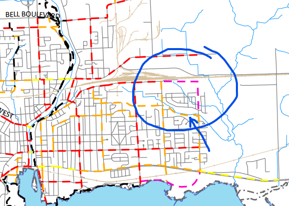
Removal of cycling trail in Stanley Park south of Bell Creek
Our concern relates to Schedule D of the OP whereby a cycling trail is shown to be located in Stanley Park south of Bell Creek immediately north of the abutting homes on Edgehill Rd. We have attached a sketch with a clip from Schedule D to show the area we are referring to. In this area, the edge of Bell Creek is literally within 1 or 2 metres of the rear yard property lines of the homes in this area.
This trail is inconsistent with other parts of the OP, namely:
– This is an environmentally protected area (as per the OP). The cycling network is identified as “active transportation” within the OP document while EP areas are supposed to be restricted to no more than passive recreation.
– There is insufficient space between the creek and the rear yard property lines throughout most of this area. Furthermore, there is an extreme change in grade between the creek and rear yard property lines throughout this area (anywhere from 2 to 4m). Therefore, a cycling trail is not able to be physically constructed without contravening the requirements of Section 3.5 of the OP.
– This area is a wetland area (Provincially Significant Wetland) and is prone to flooding. The proposed cycling path is within the floodplain.
– Construction of this type is inconsistent with the Provincially Significant Wetland designation.In most, if not all, other cases, this cycling trail network is located within streets, where it belongs.
Even if this Schedule is meant to simply be a concept it should not contain concepts that are inconsistent with the OP’s own requirements.
If this trail is allowed to remain to be shown in this Schedule residents are concerned that when it comes time to construct it we will be told that it is part of the OP and we should have objected to it through the OP process. At that point there is no other appeal process available to the residents.
Therefore we are requesting that this line be removed from this schedule.
Comment
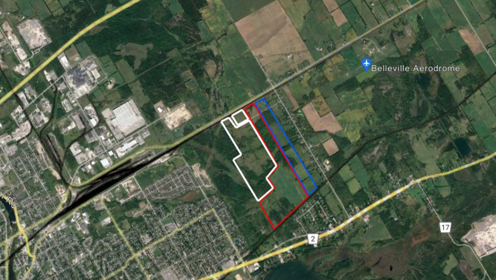
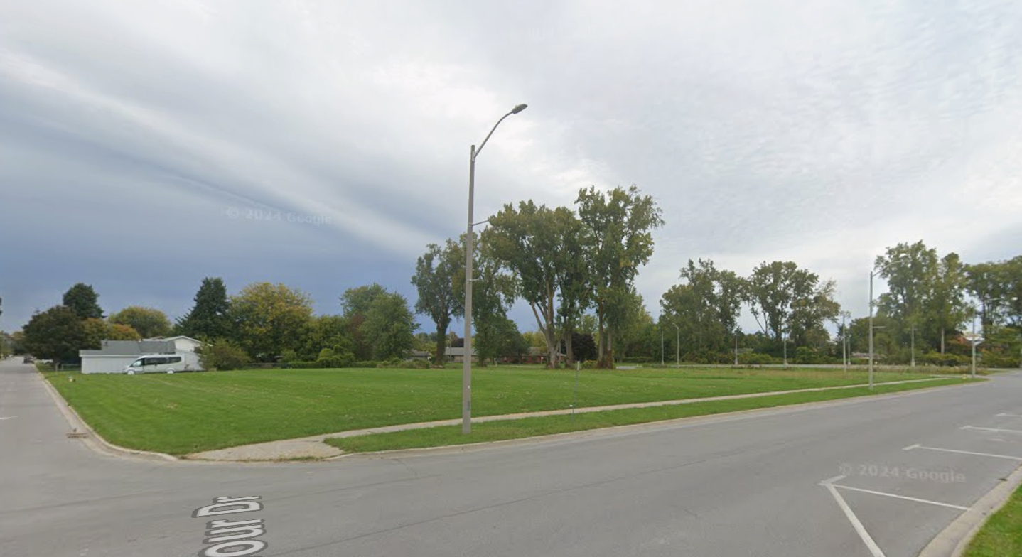
Convert 40 Wilson Avenue, Belleville brownfield property vacant since 2016 to residential use
Include 400 acres from CN tracks on the north to CP tracks on the south in Belleville “Urban Area”
I own 125 acres between Bell Creek and Elmwood Drive, being the north part of pt lot 15 and north part of pt lot 16. Part lot 15 is included in the City’s “urban area” and zoned residential -holding. Part lot 16 is zoned Rural residential I along with the neighbouring land owners Raycroft/O’Neill and Mary Fox (all lands totalling about 400 acres from CN tracks on the north to CP tracks on the south) would like that all our lands should be included into the Belleville “Urban Area” up to and including all the homes fronting onto Elmwood Drive. Zoning to be Residential-holding.
We are in regular communication with Belleville Planning department and we are told that they see the merit to do this inclusion so that over the next development time horizon all these lands can be planned at the same time for infrastructure of water, gas and sewer.
We have had engineering plans done now for 20 years and are always ready to do the required updates.
We have currently commissioned the updated environmental.
This land area could likely accommodate about 1,500 dwellings quickly because the land is high and dry (now open fields) with city owned roads (Antrim Road) and many road allowances already in place.We are very keen to protect the adjoining designated wetlands and envision building dwellings with no reduction of the PSW; and with opening up of greater access to the PSW for the residents of Belleville to enjoy.
We believe that this land mass is an intelligent priority location for housing given its location near to the Belleville industrial park — employment lands and because its topography should yield an ease of servicing.
Presentation available for further discussion as appropriate.
ERO
Moving rural farmland and land zoned for environmental protection into an “Urban Area” designation is essentially the process of unlocking its “highest and best use.” The most immediate benefit is a substantial increase in land value. By moving this into the Urban Area with Residential zoning, the valuation shifts from a “price per acre” model to a “price per buildable unit” model. Even if the development is phased over years, the raw land value of a parcel approved for 1,500 units is exponentially higher than 400 acres of rural land.
Extending municipal services (water/sewer) to the northern boundary of the Urban Area is expensive. Spreading this cost across 400 acres and 1,500 units makes the project financially viable, whereas developing only your 125 acres might be cost-prohibitive.
Ford government’s decision
Modifications
- Adding: “The Black Bear Ridge Village is centred on the transformation of the existing Black Bear Ridge golf course into a master planned resort.”
- For clarity, development and site alteration shall not be permitted in fish habitat except in accordance with provincial and federal requirements.
- Reduced the involvement of the Conservation Authority.
- Allowing 3 units as-of-right.
- Stormwater management studies only reviewed and approved when appropriate.
- Removal of reference to Section 1.3.2.4 of the PPS.
- Changing brownfield site incentives from bonusing via Community Benefit Charges to grants via a Community Improvement Plan.
- Changing brownfield site incentives from bonusing via Community Benefit Charges to grants via a Community Improvement Plan.
- Adding Specific Policy Area #7 – Black Bear Ridge Village Planning Sub-Area
- Adding Specific Policy Area #8 – Old Fairgrounds Area
- Development to be serviced on private on-site sewage systems is discouraged in all vulnerable areas where it would be a significant drinking water threat. Applications for development in these areas may require hydrogeological study.
- Stormwater management plans must follow Conservation Authority guidelines only if appropriate.
- Black Bear Ridge Village only allowed to be developed on full municipal services.
- Archaeological resources found must be reported to Indigenous communities.
- Reduce dedication of recreation lands to 1 hectare for every 600 dwelling units from 1 for every 300-500 units.
- To conform with Quinte Region Source Protection Plan policies, future waste disposal sites or the expansion of an existing waste disposal site are prohibited in the vulnerable areas where they would be significant drinking waterthreats. Sites that do not require an environmental compliance approval are exempt and instead require a risk management plan in areas where they could be significant drinking water threats. Further, sewage treatment plants are prohibited in the vulnerable areas where they would be significant drinking water threats if proposed in the future.
- Removal density bonuses where affordable or special needs housing would be provided where eligible under a Community Benefit Bylaw.
- Simplifying how community benefits charges are applied.
- Removal of “visually attractive”, “character” , “sympathetic to neighbourhood character” and “protect the heritage attributes” from site plan control processes.
- Removal of applications for “bonus” variances from Committee of Adjustment consideration.
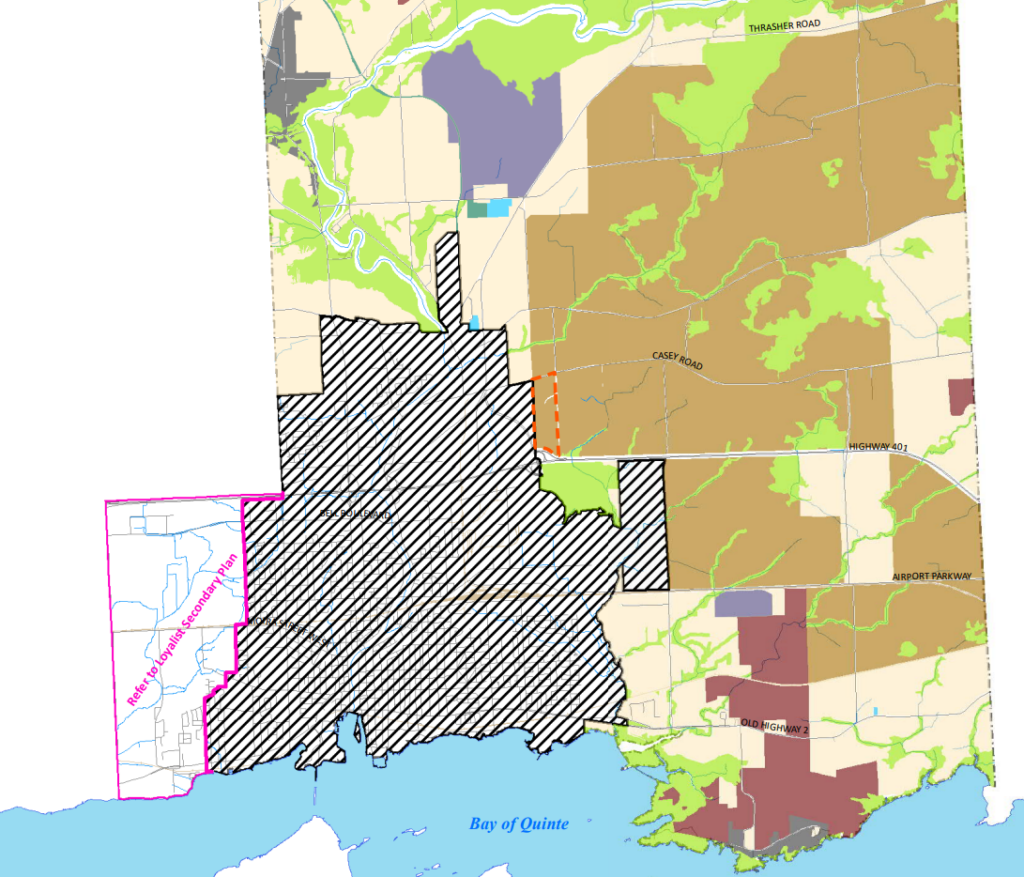
21. Granting the request of land owners Raycroft/O’Neill and Mary Fox to add their 400 acres of property to the Urban Area
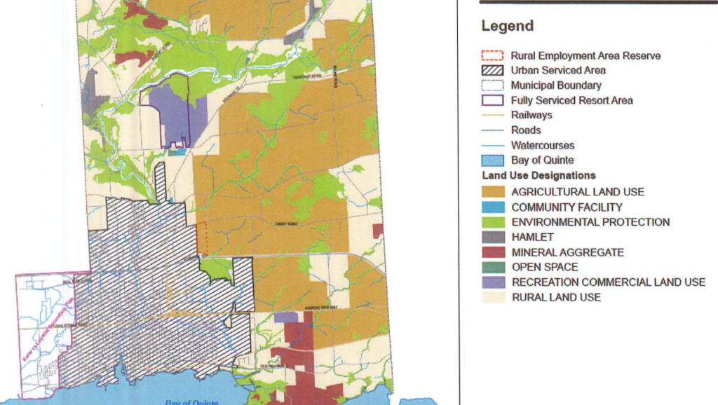
Schedule A – Land Use Plan – Rural Area” is deleted in its entirety and replaced with a new “Schedule A – Land Use Plan – Rural Area”, attached hereto in Appendix 1.
Note the addition of the to the Urban Serviced Area in the south east corner of the boundary and the outline for “Fully Serviced Resort Area” to the north for Black Bear Ridge Village:
22. Granting the request of the owner of 40 Wilson Avenue to convert it from employment to residential use
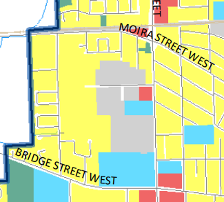
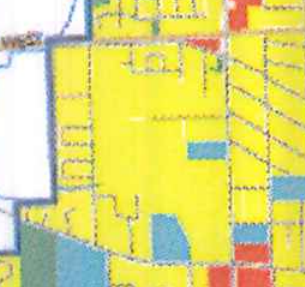
Schedule B – Land Use Plan – Urban Serviced Area” is deleted in its entirety and replaced with a new “Schedule B – Land Use Plan – Urban Serviced Area”, attached hereto in Appendix 2.
23. Adding detailed Planning Areas Old Fairgrounds and Black Bear Ridge Village to the map
Schedule E – Detailed Planning Areas” is deleted in its entirety and replaced with a new “Schedule E – Detailed Planning Areas”, attached hereto in Appendix 3.
24. Adding 40 Wilson Avenue to the “Additional Intensification Areas”
“Appendix A – Additional Intensification Areas” is deleted in its entirety and replaced with a new “Appendix A – Additional Intensification Areas”, attached hereto in Appendix 4.


Comments
We want to hear from you! Share your opinions below and remember to keep it respectful. Please read our Community Guidelines before participating.