Here are the ways to find who owns a particular property in Ontario:
- Free
- Inspect the municipality’s Assessment Roll
- Search the municipality’s records
- Search Openroom or Canadian Legal Information Institute (CanLII), if property has been involved in a court order
- Paid
- Buy a copy of the Parcel Register from Ontario Land Registry Access (OnLand) – $35.68 per property
- Teranet eXpress – $35.68 per property
- Geowarehouse – Real estate professionals have access to this software ($3,804/year)
Inspect the municipality’s Assessment Roll
An Assessment Roll lists all properties in a municipality and according to Section 14 of the Assessment Act, must contain:
Section 14, Assessment Act
- The name and surnames, in full, if they can be ascertained, of all persons who are liable to assessment in the municipality or in the non-municipal territory, as the case may be.
- The amount assessable against each person who is liable to assessment, opposite the person’s name.
- A description of each property sufficient to identify it.
- The number of acres, or other measures showing the extent of the land.
- The current value of the land.
- The value of the land liable to taxation.
- The value of land exempt from taxation.
- The classification of the land.
- Such other information as may be prescribed by the Minister. 2006, c. 33, Sched. A, s. 13 (1).
Assessment Rolls are stored as hard copies/microfilm, so you will need to visit the municipality’s archives in-person to see them.
To access them, send a request to your municipal clerk asking to inspect the assessment rolls.
Search the municipality’s records
If a property owner has filed application(s) with the municipality requesting variance or rezoning, then the owner’s name is likely included in the public record.
For example, here is the Application for Minor Variance of 316 Front St. in Belleville, which states the owner’s name is Adrian Digiovanni:
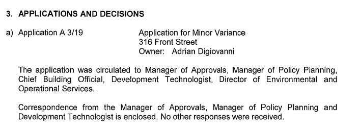
Search for “owner”, “applicant” or the address in the municipality’s meeting agendas, minutes and reports.
Buy a copy of the Parcel Register
Parcel Register
A Parcel Register is a high-level snapshot that shows the property’s ownership, solvency and history. It includes transfers, charges, discharges, or other documents, affecting a particular property, as registered in Province of Ontario Land Registration Information System (POLARIS).
Parcel Register vs Property Title Search
A Parcel Register is not a Property Title Search but rather a major component of one. A Property Title Search will not only include reviewing the Parcel Register but also examining any registered instruments and plans.
This is what a Parcel Register looks like:
And here is how to read a Parcel Register:
Through a Parcel Register you can view a property’s:
- Legal description
- Property Information Number (PIN), a unique nine-digit number assigned to each property, consisting of a five-digit block number and a four-digit property number.
- Current homeowner(s)
- Type of ownership
- % of ownership
- A history of charges, transfers, discharges, and documents registered against the property.
It also allows you to check for liens against a property. If there is, there will be an instrument number, which can be used to look up the Instrument Image.
Teranet
Founded in 1991, Teranet is a private company that operates the Electronic Registration System for the Province of Ontario. It is owned by Ontario Municipal Employees Retirement System (OMERS), a Canadian public pension fund and one of Canada’s largest defined benefit pension plans.
In 2010, the Province of Ontario agreed to a 50 year extension to Teranet Inc.’s monopoly in providing electronic land registration in return for a $1 billion up front payment to be used to reduce the province’s debt and annual royalty payments beginning in 2017, starting at approximately $50 million annually, and growing in future years thereafter.
They operate a number of software services that provide access to land records for different types of users:
Ontario Land Registry Access (OnLand) – $35.68
OnLand is Ontario’s virtual Land Registry Office (LRO) and a product of Teranet Property & Registration Services. It is a self-serve website available to the public that allows you to access Parcel Registers.
Note: Getting a copy of the land transfer documents does not mean you will find out the beneficial ownership. You will see the “title holder”, but this may not be who ultimately owns the property. For example, a numbered Ontario company may be listed eg. “123456 Ontario Inc.”, obscuring the name of the beneficial owner.
To get a copy:
- Go to OnLand
- Enter the city, town, or LRO name, or number you’d like to search in to find your Land Registry Office (LRO)
- From the Find your land registry service options, select Property.
- Select the Address option.
- Enter the address details.
- In the Requested By field, enter your name, or the name of the person on whose behalf you are searching.
- Click Search.
- Selecting the date and language options in the Parcel Register options on the page and click Add to Cart. Then proceed with payment.
You can pay by debit or credit, and you can provide an email address to receive your document, or download it, or both.
Each document in the Property Parcel has a Registration Number. To get copies of any those documents (e.g. a lien), go to “Documents->Instruments, Plans and Evidence” and enter the appropriate Registration Number. So if you did have an unexpected lien, you should be able to get details from there. It looks like copies of such documents cost $3 plus HST.
If you think you’ll need this information in court, you’ll need to pay another $2 to get a “Certified Copy”.
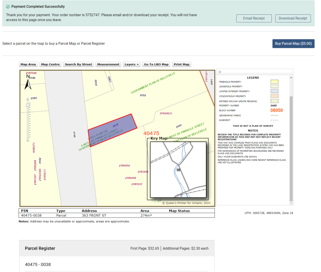
NOTE: Don’t bother paying to view OnLand’s $5 map, it doesn’t provide any information that can’t be found through your municipality:
Instrument Image
A registered document within the Land Registration System of Ontario that can include liens, mortgages, transfers, and condominium declarations, among others.
Here is an example:
Teranet eXpress – $35.68
Teranet eXpress is a self-serve website available to the public that allows you to access:
- Parcel Registers
- Individual office writs filed and entered into the Ontario Writs System.
- Writs simultaneously across all 49 Enforcement Offices.
You can search by surname, address or PIN. Almost anyone can register and it is primarily used by legal professionals and individuals.
Their fees are as follows:
Teraview
Teraview is a software platform owned by Teranet Property Search & Registration Services that is intended for use by professionals who have to look up properties frequently. It costs $595.00 per package.
GeoWarehouse
GeoWarehouse is a software platform owned by Teranet used by real estate professionals that is a complete data source for all real estate transactions. Ontario real estate agents have access to access to the GeoWarehouse platform through your membership in a participating Real Estate Board.
If you have a real estate agent friend, they may be willing to look up on GeoWarehouse who is currently listed on title for the real property.
Access to the software costs $3,804 per user per year (adding assessment values adds $6,340 per user per year) and includes the following data:
- Search every parcel in Ontario
- Search in all municipalities in Ontario
- Secure property and land legal ownership
- Access the legal description of the property
- Search by address, PIN, name, ARN, or instrument plan
- Search lot & concession
- Access property identification number (PIN)
- Lot & perimeter size
- View historical market trends
- Verify sales history information for the property
- Access measurement tools
- Condo details search that shows related ownership (lockers/parking/storage)
- View measurement of the lot area
- Search neighbourhood sales
- View demographics reports
- Access the store for additional due diligence (parcel register, instrument images, etc.)
- View school catchment areas
- Generate customized property reports in PDFs
- Access various map views (aerial/street/45-degree)
- View/select adjacent parcels
- Access various heat maps for research
- Access live training and support
Historical property ownership records
- Archives of Ontario – For assessment rolls before 1997. Search for the municipality’s name + “assessment” or visit the Archives of Ontario in North York in person.
- OnLand – Historical Books – For property records registered prior to the introduction of Ontario’s electronic land registration system
- FamilySearch.org to search for any land records that have been digitized by the organization by county. As these were digitized separately, the scans may be of better quality and they are free to access and download.
How to find Plan, Lot and Concession numbers on a map and get an address
Ministry of Agriculture, Food and Rural Affairs
- Visit AgMaps – Ministry of Agriculture, Food and Rural Affairs (wait a few moments for disclaimer to appear)
- Scroll down and accept the disclaimer
- Scroll in to the area of interest
- Click the Layers tab
- Click Select Map Layers
- To view Assessment Parcels, click + beside Parcels and check Assessment Parcel
- To view Township, Lot and Concession boundaries, click the + beside Administrative and check Geographic Township and Lots
- To get an address (if available), Latitude or Longitude, right click the highlighted area.
Ministry of Natural Resources and Forestry
- Visit Make a Topographic Map – Ministry of Natural Resources and Forestry (wait a few moments for disclaimer to appear)
- Scroll down and accept the disclaimer
- Click the Search tab
- Click Search by Location
- Select
- Search for a Township & Lot/Concession on a map
- Search for a parcel by assessment roll number
- Select the Township, Concession and Lot numbers from the drop downs and click Search
- To get an address (if available), Latitude or Longitude, right click the highlighted area.
- Parcel location and shape
- Roll number
- Parcel ID

Comments
We want to hear from you! Share your opinions below and remember to keep it respectful. Please read our Community Guidelines before participating.